Publishing History > Black's Guides (Adam & Charles Black) - Book Series List
Black's Guide Books for Tourists
(later known as: Black's Guides)
Publisher: Adam & Charles Black. Country: U.K. Date: 1839 - c. 1919.
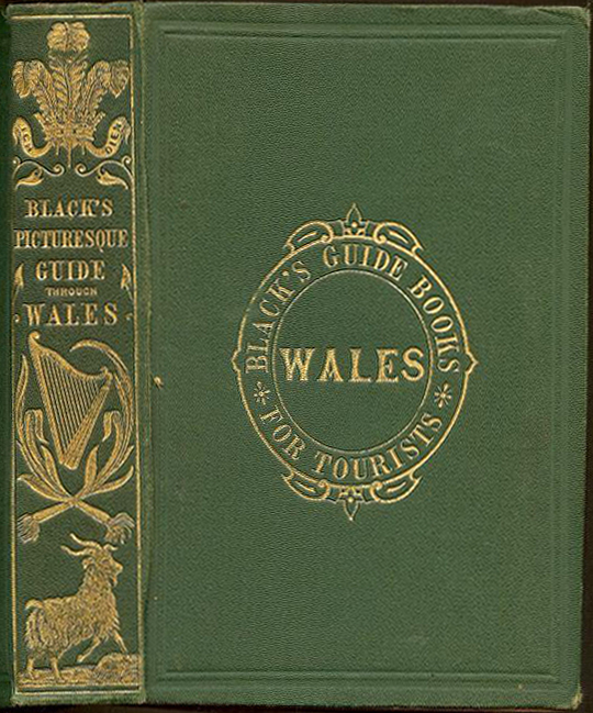
Black's Picturesque Guide Through Wales
Edinburgh & Chester: Adam & Charles Black, 1865 (Black's Guide Books for Tourists). 14th edition.
Hardback in green cloth with gilt title and tooling to upper cover and spine. Frontispiece. Title page with vignette. Map end pages. (xiii), [1], [1], 2-407 pp. 7 maps (5 folding). 25 illustrations (some full page), including 13 plates. Publisher advertisements.
BLACK'S GUIDES (ADAM & CHARLES BLACK)
Series Note: The Black's Guides were travel guide books published by the Adam and Charles Black firm of Edinburgh (later London) beginning in 1839. The series' style tended towards the "colloquial, with fewer cultural pretensions" than its leading competitor Baedeker Guides. Contributors included David T. Ansted, Charles Bertram Black, and A. R. Hope Moncrieff.
Black's Guides Available in 1876
Aberdeen and Braemar.
Alton Towers and Dovedale.
Belfast. Giant's Causeway and north of Ireland.
Brighton (Worthing, Newhaven).
Buxton.
Channel Islands (Jersey, Guernsey, Alderney, and Sark). Profusely illustrated.
Cheltenham and Environs.
Cornwall (and Scilly Isles). With Map and Plans.
Derbeyshire (Buxton, Matlock, Chatsworth). With Map of the County, Plan of Chatsworth, and several Illustrations.
Devonshire (Torquay, Exeter, Plymouth, etc.) With Maps and Illustrations.
Dorsetshire (Lyme Regis, Weymouth, Swanage, Portland, Salisbury, etc. With Map and Illustration.
Dorset, Devon and Cornwall. Complete in One Volume, With Maps and Illustrations.
Dublin and the Wicklow Mountains. With Plan of Dublin.
Edinburgh and Environs. With Illustrations.
England and Wales. Containing a General Travelling Map, Charts of Railroads, Plans of Towns, etc.
English Lakes. Including an Essay on the Geology of the District. By Professor Phillips of Oxford. With twelve outline Views by Mr. Flintoft, and Illustrations by Foster.
English Lakes. Cheap Edition.
Galway, Connemara, and the Shannon.
Glasgow and the Clyde.
Gloucester (Bristol, Cheltenham, Clifton, etc.)
Guernsey and Sark.
Hampshire (Southampton and Portsmouth.)
Harrogate.
Hereford and Monmouth.
Ireland. Illustrated with Map of Ireland and several Plans and Views. Fifth Edition.
Isle of Wight (Cowes, Newport, Ryde, Ventnor, Osborne, Carlsbrook, etc.) With Maps and Illustrations.
Jersey (St. Heliers, &c.)
Kent (Gravesend, Dover, Folkestone, Margate, Ramsgate, Woolwich, Tunbridge). With numerous Illustrations.
Killarney and the South of Ireland. With Chart of the Killarney District and Plan of Cork.
Leamington and Environs.
Leeds and Vicinity.
Liverpool and Birkenhead. With Plan of Liverpool.
London and Environs. With Map, Plans, and numerous Illustrations.
Manchester and Salford.
Moffat and St. Mary's Loch.
Nottinghamshire.
Scarborough and Whitby. With Map, Plans, and Views.
Scotland. With upwards of One Hundred Illustrations, consisting of Maps, Charts, Plans, and Views.
Scotland. Cheap Edition.
Scotland. Diamond Edition.
Skye and West of Ross-shire.
Spain and Portugal (O'Shea). Illustrated by Charts and Plans of Towns introduced throughout the text, and a general Map of Spain.
Surrey (Sydenham, Wimbledon, Croydon, Reigate, Guildford, Aldershot, Richmond). With
numerous Illustrations.
Sussex (Lewes, Brighton, Newhaven, Chichester, Hastings, etc.) With Map and numerous Illustrations.
Sutherland.
Trossachs and Loch Lomond. Illustrated by Birket Foster.
Wales, North and South. In One Volume. Illustrated by Maps, Charts, and Views of Scenery. Thirteenth Edition.
ALSO:
- North Wales.
- South Wales.
- Wales. Cheap Edition.
Warwickshire (Birmingham, Kenilworth, Stratford).
Where Shall We Go? A Guide to the Healthiest and most beautiful Watering Places in the British Islands. Illustrated with Maps and Engravings.
Yorkshire. With Map of the County, and numerous Plans and Views. Fourth Edition.
York (city) and its Antiquities.
Source of the above 1876 list:
Black's Guide to Nottinghamshire. Capt. A. E. Lawson Lowe, ed. Edinburgh, Adam and Charles Black, 1876.
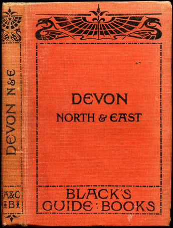
Black's Guide to Devon Part II: North and East
by J. E. Morris
London: Adam & Charles Black, Ltd., 1926.
Hardback binding in strawberry cloth covers with black title lettering to the spine and to the upper panel. 8vo. 7'' x 5''. Pages: [xvi], 128, [50]. Eight monochrome maps and plans and four photographs. End paper maps. Colour county map to the rear.
** FURTHER READING **
Alexander Nicolson, ed. (1885), Memoirs of Adam Black (2nd ed.), Edinburgh: A. and C. Black
Sara Blair (2004). "Local Modernity, Global Modernism: Bloomsbury and the Places of the Literary". English Literary History 71.
"New Books". Scottish Geographical Magazine. August 1888.
Katherine Halda Grenier (2005). Tourism And Identity in Scotland, 1770-1914: Creating Caledonia. Ashgate Publishing.
Share this page:
Author: David Paul Wagner
(David Paul Wagner on Google+)
|